.
.
.
.
.
.
.
.
.
.
.
.
.
.
.
.
.
.
.
.
.
.
.
.
.
.
.
.
.
.
.
.
.
.
.
.
.
.
.
.
.
.
.
.
.
.
.
.
.
.
.
.
.
.
.
.
.
.
.
.
.
.
.
.
.
.
.
.
.
.
.
.
.
.
.
.
.
.
.
.
.
.
.
.
.
.
.
.
.
.
.
.
.
.
.
.
.
.
.
.
.
.
.
.
.
.
.
.
.
.
.
.
September 20 2006 - 120th Anniversary of the Annexation of "Kanemiloha'i" by the Kingdom of Hawai'i and the shipwreck of the "Dunottar Castle".
A set of 2 postage stamps and a mini-sheet were issued on September 20th 2006 to celebrate the 120th Anniversary of the Annexation of "Kanemiloha`i" (Kure Atoll) by the Kingdom of Hawai'i and in memory of the shipwreck of the British ship "Dunottar Castle" there in 1886.
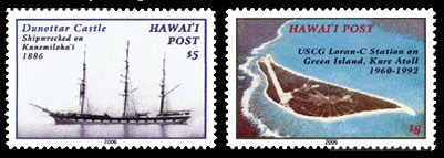
The $5 stamp (above left) prepays the overnight rate. It shows a black and white photo of the Dunottar Castle.
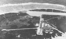
The $8 stamp (above right) prepays the same day rate. It shows an aerial view of Green Island on Kure Atoll, and the USCG Loran-C Station (1960-1992) and the airfield built during WWII.
"Kanemiloha`i" is the Hawaiian name for the atoll and means the brother of Pele. It lies about 1,175 nautical miles northwest of Kaua'i and about 55 miles west of Midway Island. It is the westernmost atoll in the Northwestern Hawaiian Islands Marine National Monument. The atoll is all that remains of a 28 million-years-old shield volcano. It is a circular atoll, with a reef about 15 miles around and about 6 miles across. Treacherous waves, up to 30 feet high, sweep across the reef most of the year. It is the world’s northernmost coral atoll at latitude N28.25° and longitude W178.20°. The large lagoon can only be accessed by a small boat through a shallow opening in the reef on the southwest side, and a very small southwest of Green Island. It has several unique flora and fauna. The main island in the atoll is Green Island which consists almost entirely of tall sand dunes rising as high as twenty feet. The International Date Line lies approximately 100 miles to the west.
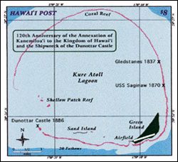
The $8 mini-sheet (above) prepays the same day rate. It shows a map of Kure Atoll and the location of 3 shipwrecks.
Kanemiloha`i has had a colorful history, especially regarding shipwrecks. The atoll was originally discovered by Captain Benjamin Morrell Jr. of the schooner "Tartar" in 1823. The Russian ship "Moller" commanded by Captain Stanikowitch re-discovered the atoll in 1827 and named it after Captain Kure, a Russian navigator. The British ship "Gledstanes", commanded by Captain Brown, was wrecked there on July 9th 1837. The survivors lived on Green Island where they assembled a boat from fragments of the shipwreck. On December 15th 1837, Captain Brown sailed away and managed to reach Honolulu where a ship was sent to the atoll for the rest of the survivors. The American whaling ship "Parker" was wrecked on the atoll on September 24th 1842. All survivors were rescued after 6 months or more stranded there.
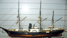
Model of the USS Saginaw
The most well-known shipwreck was that of the paddlewheel gunboat USS Saginaw. This ship was at Midway Island in March 1870 with a party of divers and engineers dredging a passage through the reef into the Midway lagoon. However, the $50,000 appropriated by the U.S. Congress for the job ran out so it was not completed. Before returning to San Francisco, Captain Montgomery Sicard decided to visit Kanemiloha`i to see if there were any more castaways left there. However, on October 29th 1870, the USS Saginaw ended up as a shipwreck on the atoll itself. There were 98 survivors. Five of them set off in a boat, making it to Kauai in thirty days. However, the boat rolled in the heavy surf, and they were so weak that only one managed to get ashore, the rest drowned. Upon the news reaching Honolulu, the ship "Kilauea" left on December 26th 1870 arriving at the atoll on January 3th 1871 and brought the remaining survivors home.
The "Dunottar Castle", a 258-foot, three-masted British saling ship, sailed from Sydney Australia on June 9th 1886 with a cargo of coal. The "Dunottar Castle" was named after a well known castle near Aberdeen in Scotland. Because of faulty navigational instruments, the ship strayed off course and struck a reef at the entrance to the lagoon of Kanemiloha`i and was wrecked there on July 15th 1886. The 28 crew members all survived. 22 of them stayed behind on the atoll while 6 crew members took to the sea in a small boat on July 24th 1886 with less than a month's supply of water and provisions. After 52 days at sea, they managed to reach the island of Kaua'i. News of their arrival quickly reached Honolulu where the British Commissioner, Major James Wodehouse, decided to send out a ship for the remaining crew. Hearing of this and fearing the British might lay claim to Kanemiloha`i, King Kalakaua came to an agreement with the British Commissioner by sharing expenses and the steamship "Wai'ale'ale" with Colonel James Boyd aboard sailed to the atoll. Arriving there on September 20th 1886, he took possession of Kanemiloha`i for the Kingdom of Hawai'i and the Hawaiian flag was raised. But the atoll, although showing signs of recent habitation, was completely deserted. A note found in a bottle attached to a wooden post explained that the ship "Birnam Wood" had picked up the survivors already. The "Birnam Wood" was on its way from Hong Kong to Valparaiso, Chile. A makeshift house was built on the island, with water tanks and some provisions for future castaways. This fell into disrepair in later years.
On February 15th 1894, the Provisional Government of Hawai'i leased the atoll to the North Pacific Phosphate and Fertiliser Company for 25 years. However, no extensive guano extraction was done during that time.
Renamed Kure Atoll, it was annexed by the United States on July 7th 1898 when the Republic of Hawai'i became a U.S. Territory. In April 1909, it became part of the Hawaiian Islands Bird Reservation.
| The Tanager Expedition, the first scientific expedition to Kure Atoll, took place in 1923. The expedition's name came from the ship that took the scientists from Honolulu to the Northwestern Hawaiian Islands. The "Tanager" (pictured at right) was a converted minesweeper from the First World War. Various flora and fauna were collected, studied and preserved for shipment back to laboratories in Honolulu. | ... | 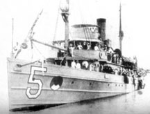 |
Then, nothing much happened on Kure Atoll until World War II when an auxiliary airstrip, approximately 4000 feet long, was built on Green Island.
The LORAN station at Kure Atoll |
... | In 1960, a LORAN (Long Range Aids to Navigation) Coast Guard Station was built on Green Island with two 158 meter high masts. Supplies usually came by a USCG ship from Midway. The LORAN station was closed in June 1992 when the GPS (Global Positioning System) using satellites became a preferred navigational aid. In July 1993, the USCG returned to Green Island and demolished most of the LORAN structures and improvements. Heavily contaminated soil was removed from the island. Lesser contaminated soil was buried in a landfill in the middle of the island which was landscaped so as not to affect wildlife. At the same time, a rat eradication program was implemented on the island. |
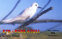
Card from the 1997 DXpedition (K7K) |
... | Because of its northerly position, distant communication with Kure Atoll is particularly popular among European amateur ham radio operators. Two DXpeditions (Amateur Radio DX expeditions) cards are shown. | ... |
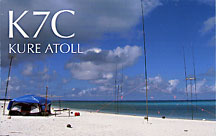 The 2005 DXpedition (K7C) consisted of 12 Amateur Radio operators from the USA, Canada & Germany. |
It was an unusually calm day in July 2006 when staff of the State Wildlife Refuge were sailing in a small boat across the lagoon at Kure Atoll when they looked down and saw a shipwreck through the crystal clear waters. Normally the water is not so clear as it is churned up by the very high waves that crash upon the reefs. It was soon determined that the wreck was the remains of the "Dunottar Castle". Although many items have been carried away by the ocean currents over the 120 years it has rested about 4 fathoms or so at the bottom of the sea floor, much of the ship is preserved and, because of it's remote location, has not been looted.
To-day, Kure Atoll is one of the many atolls and islands that make up the Northwestern Hawaiian Islands Marine National Monument. Prior written permission is required before anyone can land on the atoll due to the delicate ecosystem there.
An Official Hawai'i Post First Day Cover was also issued with a special cachet and postmark for the occasion.
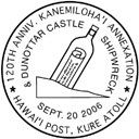
The special postmark for this issue (above) shows a message in a bottle. This was typically used by shipwrecked sailors in the 19th century to get help. Black ink was used.
WE ACCEPT CREDIT CARDS ON ALL ORDERS
![]()
![]()
![]()
![]()
Technical details of the stamps and mini-sheet:
Colors: $5 and $8 stamps and $8 minisheet - Multicolored
Stamps sheet size: 30 - 5 across and 6 down. Mini-sheet - 70mm x 63mm.
Perforation: Perf 12. The mini-sheet is imperforate.
Mini-sheet and stamps design: Enelani.
Layout & Pre-press: Enelani.
Printer: Hawai'i Security Printers, Honolulu, Hawai'i.
Printing Method: 4-color (Cyan, Magenta, Yellow and Black) Thermal printing process.
Sheet margin markings: HAWAI'I POST (top middle), "Traffic Light" showing 4 colors used in printing (lower left side), © 2006 Hawai'i Post (lower right side) & Hawai'i Security Printers, Honolulu, Hawai'i. (bottom middle)
Paper: GPA coated white stock with water-activated gum on the back.
Some information and illustrations courtesy of the N.O.A.A. (National Oceanic & Atmospheric Administration).
Return to list of stamp issues
For details on upcoming stamp issues click here